UPDATE: 9 P.M. FRIDAY, JAN. 31
A smartphone and email-based alert system is in place, as Maple Ridge braces for potentially severe flooding overnight.
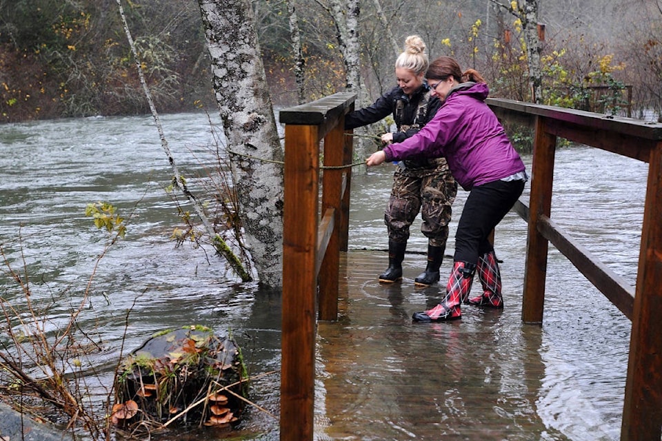
As of about 8 p.m. this evening, there was flooding reported along 132nd Avenue between 216th and Edge Streets, as well as on 224th Street north of 132 Avenue.
Road closures are in effect until the water levels recede, the municipality said in an urgent web alert.
“High rainfall amounts have resulted in localized flooding in some areas of the community and the forecast is for continuing heavy rain through the night,” the most recent update stated.
There are also reports of flooding in the Hammond neighbourhood, as a result of rainfall accumulations in the Katzie Slough.
The dike water pump that services that area has been working at capacity for a number of hours to move water from the Slough into the Fraser River, the update specified.
Further, citizens are reporting ponding water on private property and on roadways in other areas of the community due to the heavy and sustained rainfall.
“The risk of additional flooding remains for both the North and South Alouette River and other watercourses around the city are experiencing high volumes as the weather system moves through the region into Saturday morning,” said the municipal update.
Due to localized flooding some roads have been closed in the community. We remind citizens that they need to respect the barricades and road closures no matter what type of vehicle that they are driving. Updates have been posted on the City website and Facebook. pic.twitter.com/ezsGEYUD2c
— City of Maple Ridge (@YourMapleRidge) February 1, 2020
BC Hydro is currently doing a controlled release from the Alouette reservoir in to the South Alouette River and Stave Lake systems to address the accumulation of precipitation in the reservoir.
Rainfall amounts in the high side of the forecast may result in a free crest from the reservoir into the spillway for a period of time until the rain eases.
City staff are monitoring conditions closely issuing updated advisories on the City website at mapleridge.ca as new information becomes available.
Citizens who live in proximity to the North or South Alouette river are encouraged to sign up for push notifications to their email or smartphone by clicking on the ‘Stay Connected’ icon on the City homepage at mapleridge.ca.
There is a specific ‘Alouette River Urgent Alerts’ notification that pushes the latest updates to people’s emails or mobile device based on their choice setting up the notifications.
In the meantime, residents who live along the river are encouraged to review their personal emergency preparedness for flooding.
The flow rates for all local streams and rivers is extremely high and people should use extra caution along watercourses.
•••••
EARLIER COVERAGE:
Alouette River is rising and BC Hydro said the river will be at flood level this Friday evening.
“The contribution of flood routing discharges from the Alouette dam and local downstream inflows are expected to exceed the flood alert level of 85 metres per second,” a BC Hydro flood alert notice said Friday afternoon. Local flooding can occur when the river flow exceeds 85 cubic metres per second.
“We are seeing water levels rise on the river to potentially be at flood level. That’s more certain now,” BC Hydro spokesperson Tanya Fish said Friday afternoon. That’s due to a discharge from the river and tributaries flowing into the South Alouette River.
Read more: Weather watch on in Maple Ridge
Total flows could reach between 100 to 150 cubic metres per second, BC Hydro said.
Meanwhile, there’s still a 50-50 chance that water could flow over the top of dam and down the spillway into the river, Fish added.
“The Alouette reservoir is nearing full pool,” said BC Hydro.
If more rain falls, “additional flow may be passed into Alouette River as early as late Friday evening from the spillway,” Hydro said.
The agency is working with the City of Maple Ridge to keep residents informed.
The City of Maple Ridge has posted website and social media alerts to warn people living along the North and South Alouette River to the risk of flooding due to the high rainfall amounts forecast over the next 36 hours.
A rainfall warning remains in effect from Environment Canada.
In a Friday afternoon alert on their website, the City has said heavy rain has resulted in localized flooding along 224 Street north of 132 Avenue and large volumes of water along 132 Avenue between 216 Street and 224 Street.
“City staff are monitoring the road conditions and recommend that people who use this route as part of their commute divert to other routes for the duration of this rain event,” the alert said.
“Roads may be closed on sudden notice and we ask that people respect the barricades and cooperate with traffic flaggers on site.”
They add there is a risk of flooding along both the North and South Alouette River as the weather system moves through the region over the next 24 hours. The highest rainfalls are expected over the next 12 hours, and river levels could rise quickly along all of the watercourses in the community.
PREVIOUS REPORTING: BC Hydro releasing water into the South Alouette
As mentioned above, BC Hydro are currently doing a controlled release from the Alouette reservoir in the South Alouette River and Stave Lake systems to address the projected rainfall coming into the reservoir.
City staff are monitoring conditions closely over the next 24 hours and issuing updated advisories on the City website at mapleridge.ca as new information becomes available.
The city is recommending that citizens who live in proximity to the North or South Alouette river sign up for push notifications to their email or smartphone by clicking on the ‘Stay Connected’ icon on the City homepage at mapleridge.ca. There is a specific ‘Alouette River Urgent Alerts’ notification that pushes the latest updates to people’s emails or mobile device based on their choice setting up the notifications.
EARLIER ALERT: Possibility of flooding after heavy rains predicted for Maple Ridge and Pitt Meadows
Those who are at risk of flooding are encouraged to review their personal emergency preparedness for flooding. The flow rates for all local streams and rivers is extremely high and people should use extra caution along watercourses.
The City will also post updates on the City Facebook page at https://www.facebook.com/yourmapleridge.
Citizens are advised to look for the latest updates from the BC River Forecast Centre via their website.
The latest weather forecast from Environment Canada can be found online and on the provincial website.
pmelnychuk@mapleridgenews.com
Like us on Facebook and follow us on Twitter