Maple Ridge council wants shopping in a big way in the Albion flats, but it wants to see what you think about its plan first before getting feedback from the Agricultural Land Commission.
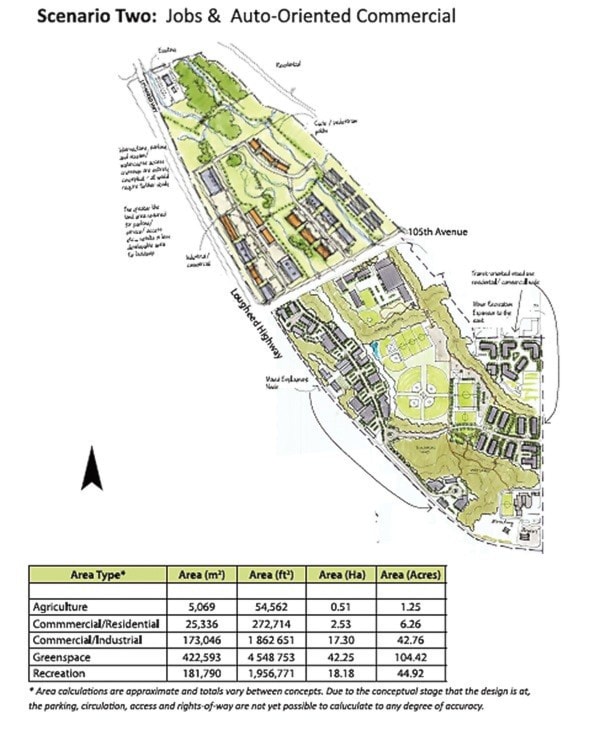
Council settled on Scenario 2 Monday, an option that calls for up 1.8 million sq. feet of commercial/industrial space in the flats along Lougheed Highway at 105th Avenue. It also agreed to add a few features from the other three scenarios, such as livestock barns, an agricultural training and research barn and a brew pub.
Those features, borrowed from Scenario 1, would go on the east side of 105th Avenue in the Scenario 2 motion proposed by Coun. Cheryl Ashlie. That would leave most of the west side of 105th Avenue, where SmartCentres mall company owns several acres, available for commercial development.
Ashlie’s proposal, though, opened a familiar division on council. Of the 310 acres that comprise the Albion flats, Scenario 2 calls for the preservation of only 1.25 acres of that for agriculture. Currently, about 219 acres are designated for farming.
“The Agricultural Land Commission is going to laugh in your face and they are going to say, ‘What are you thinking?’ “ said Coun. Craig Speirs.
“It’s not respectful to put that kind of scenario forward.”
He opposed any kind of development on the west side of 105th Avenue and said Scenario 2 will bring “death to the downtown.”
Any mixed used should take place near 240th Street, which would be a good place for a brew pub, he added.
Most of the flats (89 per cent) is within the Agricultural Land Reserve, although soil conditions make farming difficult. However, according to the consultant’s report, the commission would be unlikely to approve taking land out of the reserve on the west side of 105th because of the high quality soil.
Land on the east side, though, is more fragmented and with poorer soils, the report notes, so the chances of exclusion are greater.
Ashlie’s proposal also included an expanded recreation centre, including a sports field, as outlined in Scenario 4, on the east side of 105th, while Coun. Al Hogarth added that the plan should include alternative agricultural practices, such as rooftop gardens, environmental practices and mitigation for loss of agricultural land.
According to one of the background reports, there only will be demand for 303,000 sq. feet of commercial space by 2017 – assuming malls planned in Pitt Meadows and on Kwantlen First Nations land on Lougheed Highway don’t proceed.
By 2025, there only would be demand for up to 524,000 sq. ft.
Speirs, along with Coun. Linda King, voted against the proposal at every step.
King was concerned about flooding impacts on existing recreation buildings on the east side of 105th Avenue, if development takes place on the west side.
“We have a lot of facilities that we’ve already paid for. I just don’t think it’s a good idea.”
Possible congestion at the intersections of Lougheed Highway at Kanaka Way, 105th Avenue and 240th Street also bothered her.
She wanted all four scenarios, two that proposed minimal development on the west side of 105th, sent to the ALC for comment, as recommended by the consultant.
Council, though, rejected those two last week, considered Scenarios 2 and 4 on Monday, then opted for the former.
Details of Scenario 2 will be rolled out to the public in a few weeks at an information meeting, then will be sent on to the land commission for comments.
After that, the scenario comes back to council for further tuning before a formal application for exclusion, which will require a public hearing. Decisions from the ALC will then determine the plan that the district will write for the area.
“We can come with a plan, but at the end of the day, it’s up to whoever owns that property to fulfill that plan,” Coun. Judy Dueck said later.
Council has to consider all of the feedback it got on the Albion flats, not just that received during the consultation process last fall, and create something for the whole community, she said.
Daykin said the scenario is a 15- to 20-year plan.
Will all the stores be built in a short period of time? he asked. “I question that.”
What is the environmental impact on growing field crops, asked Hogarth.
Ashlie said that what’s proposed for the area has to be economically viable. What if a hog or turkey farm operation started on the farmland, she asked.
She favoured Scenario 2 because it involves landowners who can won’t get involved unless it is viable. She didn’t want to send forward plans that wouldn’t work economically.
But a convincing case has to be made to the commission about what the district will require that will help agriculture, in returning for removing land from the agricultural reserve, said Coun. Mike Morden.
“I don’t see us having any chance of success based on the fact I don’t see any offsets here.”
He also wanted more details about the eventual appearance of the development, will it be an asphalt concept or Whistler village concept?
Space must be allowed for an overpass across Lougheed Highway to give access to the Fraser River and the possible new West Coast Express station near the site of the former Albion ferry, Morden added.
And perhaps Jackson Farm, the 39-acre piece of farmland on 102nd Avenue the district received last year from developers, also could be part of the mix.
That land, outside the Agricultural Land Reserve, could be placed back into the ALR, as an offset for the land being removed from the ALR in Albion flats, said Morden.
Staff confirmed the land could still remain park, within the ALR.
That later brought a heated comment from Speirs: “I take great exception that you can throw Jackson Farm around as some kind of offset.”
But Daykin questioned if putting that land back in the reserve would qualify as a net benefit to agriculture.
Hogarth wanted the plan to spell out how food would be grown in alternative ways, such as on rooftops and surrounding properties and for any development to be required to use alternative energy such as solar power and geo thermal.
He said the area should be considered a frequent transit area and consideration for connecting to the south side of Lougheed Highway.