Staff rolled out plans for the long-term future of the Lougheed corridor in west Maple Ridge last week, but council sent them back with direction to do some big-city thinking.
“Let’s go big. Let’s get innovative. Let’s be open for densifying a transit corridor,” Mayor Mike Morden said Wednesday.
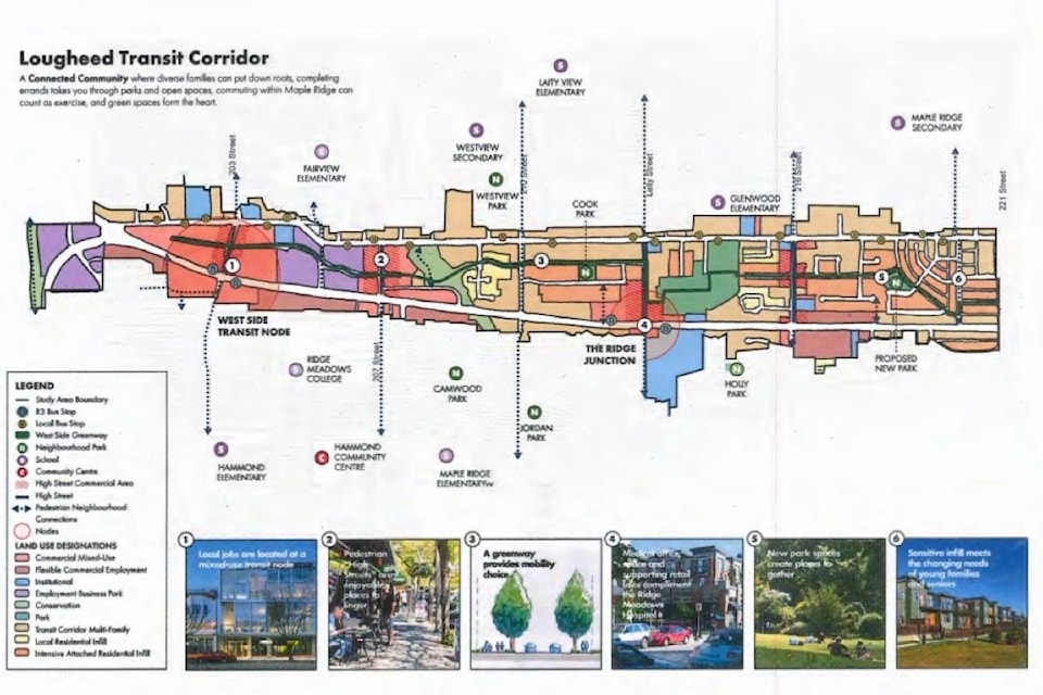
The Lougheed Transit Corridor Concept Plan tries to set out long-term development guidelines for the area between Lougheed Highway and Dewdney Trunk Road in west Maple Ridge, given the arrival of RapidBus, which starts in January.
The plan called for mixed commercial and residential use along retail streets and near transit hubs, with a maximum height of six storeys.
It also called for higher density residential along Lougheed Highway and Dewdney Trunk Road, while preserving single-family homes with sensitive infill of new housing in those areas.
Morden said at council’s workshop that the plan should utilize the new bus system that will run along Lougheed Highway.
“So really want to see us go a lot taller than six storeys and not worried about shadows,” from buildings.
He added that people shouldn’t expect that the area along Lougheed Highway will remain single-family homes.
“I don’t see that’s realistic here. We are going to go to 130,000 people. This an urban city and people need to get over that and we’re talking about these dense areas down highway corridors and the like,” Morden said.
He added the plan should ensure that employment areas are also included and there’s a focus on mixed commercial use.
“Go big or go home, as they say.”
The plan was only a concept that’s intended to guide the long-term growth of the area between Dewdney Trunk Road and Lougheed Highway, from 202nd Street to downtown.
A key part of the concept plan would be what’s called the West Ridge Greenway, a pedestrian and cycling path that roughly follows 119th Avenue and would bisect the area and run from 2o2nd to 224th streets, although several parts of that would be shared with vehicles.
The greenway would include trees, wider sidewalks and boulevards. The greenway would also be a way of connecting Maple Ridge Cemetery, McKenney Creek and Katzie Slough natural areas.
Council voted to accept the plan as information rather than endorse it.
Staff will report back to council in a few months to see if it’s possible to allow taller buildings and more mixed commercial use, although planning director Chuck Goddard said that may require further public consultation.
According to a staff report, there was “extensive” public consultation earlier this year before the plan was written, consisting of two open houses, a community survey and a design brain-storming session that in total, involved 500 residents.
Morden told staff that council was not saying no to the plan, but just seeking a bolder version.
pmelnychuk@mapleridgenews.com
Like us on Facebook and follow us on Twitter