Rain is expected to continue across B.C. over the next week, adding to late snowmelt that is causing high water in the Fraser River system and elsewhere in the province.
Emergency officials said Tuesday that the rising water is expected to peak by this weekend at 6.38 metres at the Fraser River gauge at Mission. That is well below the 8.89-metre height of the lower Fraser River dike system, so communities along the lower Fraser are not likely to experience flooding except for areas not protected by dikes.
In Maple Ridge and Pitt Meadows, municipal staff continue to monitor weather reports and are conducting periodic patrols to ensure dikes are clear and accessible.
“We want resident to be cautious around the edge of the river. It is quite something to see ... but it is dangerous,” said Pitt Meadows director of operations Kim Grout.
“As of now, it continues to be a high stream advisory and staff are continuing to monitor levels. It is very weather-dependent.”
If the Fraser peaks at 6.3 metres, it means water might rise up to the toe of the dike - that is its lowest part.
In 2007, water rose to 5.89, prompting many cities along the lower Fraser River to enact evacuation plans. Grout blames “media spin” for causing people to panic in 2007.
In Pitt Meadows, two homeowners and one business along the Alouette River, one home and two business along the Fraser were alerted to the rising water on Wednesday. The city also notified the Pitt Meadows airport as there are several hangars on the river side of the dike. Pitt Meadows will be keeping its emergency operations centre on stand-by over the weekend.
The District of Maple Ridge dropped off information to 50 homes along Wharf Street in Hammond, 40 properties near to Best Street, 90 properties fronting on Kanaka Creek just north of the Lougheed Highway, and property owners along the Fraser River from Albion to the border of Mission.
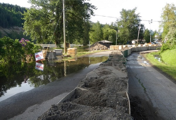
The Fraser River peaked at Prince George on Wednesday after heavy weekend rains in northern B.C.
Environment Canada meteorologist David Jones said a low pressure system off the B.C. coast is expected to spread rain to the South Coast by Friday and into the Interior by the weekend.
Interior temperatures are expected to rise to near 30 degrees before the rain arrives, accelerating snow melt in areas such as the Skeena and Bulkley watersheds where much of the snowpack remains.
The Katzie First Nations has started sandbagging areas on its Barnston Island reserve earlier this week.
- with files from Tom Fletcher
Flood Watch
• The District of Maple Ridge will be updating information on its website under "Flood Watch on the Fraser." Also follow them on Twitter @yourmapleridge and #FraserMR.
• The City of Pitt Meadows has up-to-date information on its website and via its emergency operations phone line at 604-465-2475.