No matter where you go in the province today, you won’t escape the cold.
Rain showers are expected to periodically hit several regions of B.C. until Wednesday and if you’re up in the mountains there’s snow.
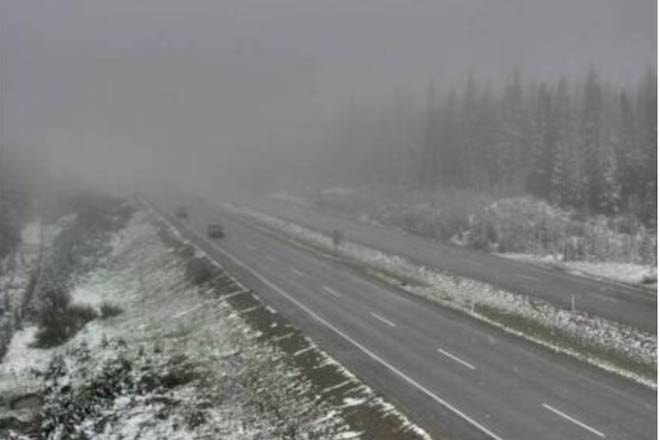
It already fell on Big White in the Okangan and some mountain passes Monday morning, closing biking trails and putting motorists on high alert. Whistler Blackcomb also got hit with the white stuff, delying the opening of their summer season Peak Chair opening.
Hello snow! July 2 and the top of the Bullet has a nice fresh dusting. Biking and hiking will remain closed for the morning, so feel free to stay cosy and warm in bed. #brrr #bigwhite #kelowna pic.twitter.com/IGY7SiCVlE
— Big White Ski Resort (@BigWhite) July 2, 2018
The cold spot for the province on Monday is Clinton, while the hottest spot is Vancouver Harbour. To the north, Terrace will reach temperatues of 19 C, while it will only get up to 13 C in the Okanagan.
The Interior of the province and the Lower Mainland could see a chance of a thunderstorm Monday afternoon, while the Island is expected to get showers through out the day.
#WBOps Peak Chair opening is delayed this morning due to snow removal. Stay tuned for updates.
— Whistler Blackcomb (@WhistlerBlckcmb) July 2, 2018
For those travelling on the Coquihalla or Okanagan Connector watch for pooling water and slippery sections due to rain. At the Pennask Summit on Highway 97 C, a dusting of snow is covering the road.
READ ALSO: IT WAS A BAD START TO JUNE
All of this, according to Environment Canada meteorologist Doug Lundquist is not the norm for this time of year.
“The average for this time of year is in the mid 20s. So for it to go from the high 30s, down to the low 20s and into the teens for highs is really a shock for us,” said Lundquist. “But, it is not unheard of for this time of year.”
Lundquist said this cooler system will not stick around long as the long-range forecast shows hot weather and sunshine returning at the end of the next week.
To report a typo, email:
newstips@kelownacapnews.com.
@KelownaNewsKat
kmichaels@kelownacapnews.com
Like us on Facebook and follow us on Twitter.