To build a road through farmland to draw traffic off another, Pitt Meadows will have to pave over much of the green space along an undeveloped commercial strip to its north.
With a price tag of $10 million, excluding the cost of land acquisition, the proposed North Lougheed Connector is a thoroughfare the city doesn’t have the cash to pay for.
Add on the costs of building an interchange at Harris Road and Lougheed Highway and the bill spikes to $31 million.
“The business case for the road is based on development,” said chief administrative officer Jake Rudolph.
“It is for regional traffic and the city’s view is that it has to be funded by other means than the city’s coffers. Development is going to be needed to trigger that road.”
Pitt Meadows council is now tasked with deciding how much of the land needs to be developed to fund it.
Three options were presented to council Tuesday by Fortune 500 company AECOM, which is leading a review of the North Lougheed land, with input from an agrologist, economist, land-use and urban planning experts, as well as a transportation engineer.
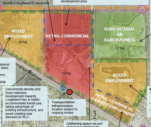
The $40,000 study is considering 50.9 hectares (125 acres) of land all the way to the yet-to-be built North Lougheed Connector, much of it agricultural.
The first option pitches development, including big stores, a hotel or conference centre, showrooms or a business park on 35 hectares (86 acres), while leaving 16 hectares (39.5 acres) for farming or other agricultural uses, like a land trust or food processing facility. It’s an option that won’t cover the costs of building the road.
The second sets aside 12 hectares (30 acres) for farming, while the third proposes developing the entire site.
Both those options would generate sufficient funds to build the 3.6 kilometre North Lougheed Connector, which would stretch from Harris Road to Golden Ears Way
The city still maintains the connector is being proposed as a way to take traffic off Old Dewdney Trunk Road. But the road is essential to service the commercial strip, west of Meadow Gardens Way.
“There’s something missing here. How do you make a plan without knowing who would be interested in moving in there,” said Coun. Bruce Bell, who favoured the options that set aside land for agricultural uses.
“We need to have agricultural somewhere in there. That’s got to be the theme if we do this.”
Coun. Gwen O’Connell preferred the option that would generate enough funds to pay for the connector.
“I am supporting this because I want traffic off Old Dewdney,” she said.
All options will be presented to the public mid-April, with a tentative date for an open house set for April 18.
Coun. John Becker suggested there was a fourth option, which entails leaving the site as is.
“It is not an economically viable one, but it certainly protects the agricultural component 100 per cent,” he said.
Mayor Don MacLean sees development on the site as a long-term project. The AECOM study estimates build-out for the entire site could take between 10 or 12 years.
MacLean would like to see a comprehensive development on the strip, so each component - retail, mixed employment and agricultural - flows into the other.
“We don’t have a whole lot of commercial land. If we are going to develop it, let’s do it right because this is the last large piece we have,” he said.
The Agricultural Land Commission approved the proposed road last July, with a caveat that requires the city to get covenants for each of the properties that will be adjacent to it. Those covenants would require each property to remain farmland.
Of the land being considered for development, only 17.5 hectares (43 acres) is zoned highway commercial, the remaining 32.5 hectares (80 acres) would have to be removed from the agricultural land reserve.
Michael Sather, the MLA for Pitt Meadows-Maple Ridge, hopes the provincial body dedicated to protecting farmland does just that.
“I don’t think any of the options are acceptable,” said Sather.
“If the ALC allows the removal of this land from the reserve, it will be a very bad precedent for the future of agriculture. It’s up to the ALC to do their job and stop this nonsense.”
@ To view maps detailing the three development options, click here.