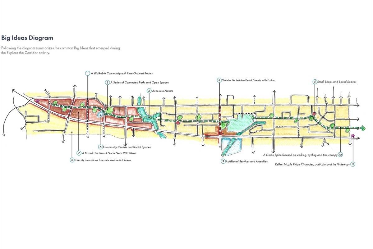
A leafy, treed east-west greenway to allow pedestrians, skateboarders, scooters and cyclists a safe way to move around, away from the traffic of Lougheed Highway and Dewdney Trunk Road, could be part of the Lougheed Highway corridor.
That greenway could roughly follow the 119th Avenue corridor, between the busy roads, and have trees, wider sidewalks and boulevards for non-motorized traffic, running from 203rd Street as far as downtown Maple Ridge.
The idea is one that’s come out of Maple Ridge’s Lougheed Transit Corridor Study, intended to plot the best future for the area as the B-line bus arrives late this year.
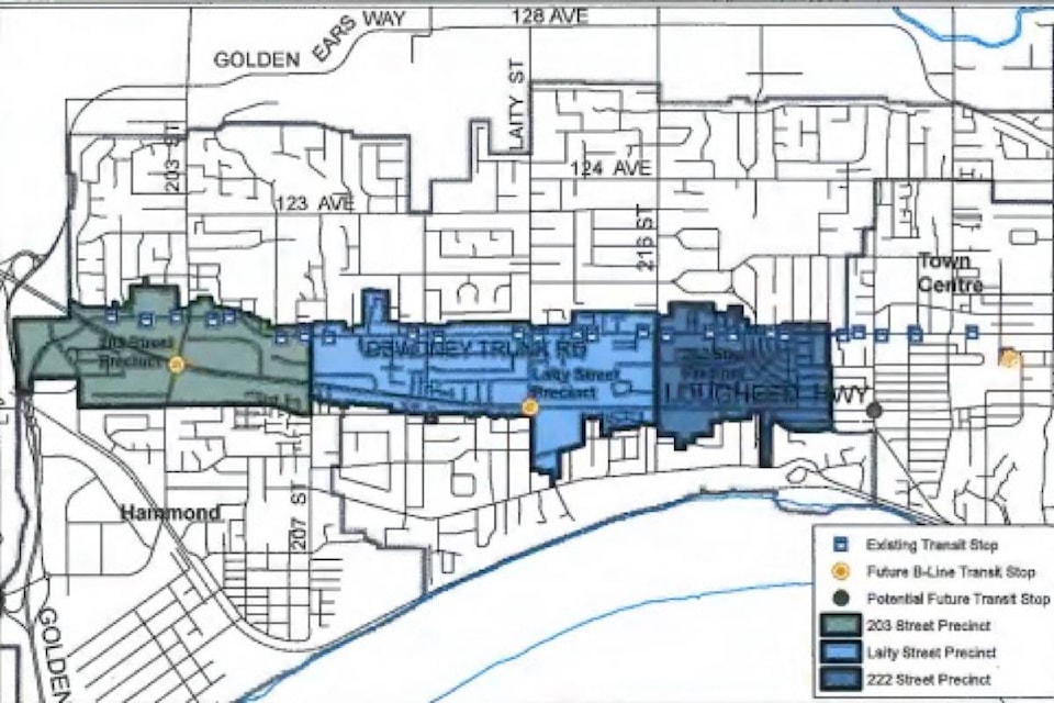
The city has already had extensive public consultation, starting last year, about the area between Lougheed Highway and Dewdney Trunk Road, stretching from downtown in the east, to 203rd Street in the city’s west end.
Coun. Gordy Robson likes what he’s seen so far. Staff are still going through the hundreds of comments and ideas from people about the corridor and will create a draft Lougheed Transit Corridor Plan for council this fall.
Council though has raised concerns about the time and effort taken so far for the study. Council was to have voted Tuesday, July 9, on whether it wanted to proceed with the complete study or just create a concept plan for the corridor.
“Actually, it’s a pretty good plan. They’re envisioning a pedestrian, cyclist-friendly, green arterial. That’s not a bad idea,” Robson said.
“You can see that might be the future gathering street. Build neighbourhoods around that so you’re not fighting with the traffic,” he added.
According to a June 25 staff report, if an area has access to transit, it can stimulate both commercial and residential development.
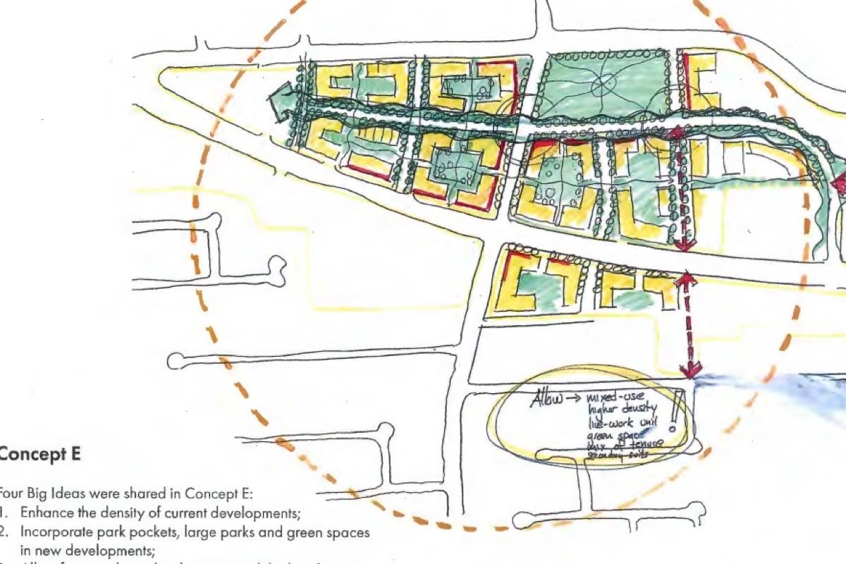
Maple Ridge city planner Amelia Bowden said the green route, would have to find a way through or around shopping malls and the Maple Ridge Cemetery and that a definite alignment for the route has yet to be found. “It would still be a vehicular road,” Bowden said.
Having sidewalks, roads, bicycle paths and transit routes all connected was a major them of the discussions, Bowden added. Many people said that they won’t walk or cycle on Lougheed Highway or Dewdney Trunk Road because they’re both too busy.
She added though that any future rapid transit service, whenever it arrives, likely will follow the Lougheed Highway.
“The Lougheed Highway is identified as our rapid transit corridor and TransLink is currently looking at what the rapid transit options may be,” east of Coquitlam.
Some of the other themes that emerged from the consultation include developing a range of commercial and residential development, green spaces, arts and cultural experiences and a streetscape that allows public transit, cycling and walking.
The study area was divided into three parts: 203rd Street., which includes the city’s second-largest shopping area; Laity Street, which includes the hospital and cemetery, and 222nd Street, considered the gateway into downtown.
The report included direct comments from residents, with one saying there should be rapid transit from Thornhill to Coquitlam centre, all day, every day.
“We do not need more roads. We need rapid transit,” the comment says.
Another notes that in 12 years, few improvements have been made to the route while the population has grown.
“SkyTrain would be nice, one day?” says another.
Yet another wanted continuous bike paths and noted there are many spots with no sidewalks.
One commenter questioned the new bike path on 203rd Street, north of Dewdney Trunk Road. It’s full of garbage and gravel and leads nowhere, one person said.
“It is completely useless.”
Yet another idea from the interactive design workshop on May 11 called for a “green Lougheed corridor” with pocket parks, roadside gardens, planted medians and green roofs.
One letter writer wanted to go further by creating wildlife corridors as part of the Lougheed corridor, and another cited Whistler as an example and that green spaces should be incorporated, while one more said stormwater management and ecological principles should be followed to minimize infrastructure costs.
pmelnychuk@mapleridgenews.com
Like us on Facebook and follow us on Twitter